

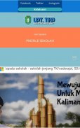

Profil Sekolah Geospasial
Profil Sekolah Geospasial介绍
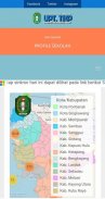
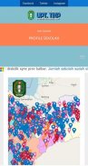
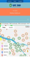
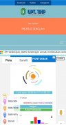
Sistem Infomasi Data Pokok Pendidikan (Dapodik) Berbasis Geospasial Aplikasi Profile Sekolah Semua jenjang di bawah Dinas Pendidikan Provinsi Kaliamantan Barat. Profile Sekolah berbasis geo spasial ini terintegrasi dengan pusat data Big Data Pendidikan Provinsi Kalimantan Barat dengan Sumber data Berasal dari Aplikasi Dapodik Sekolah, Sekolah cukup mensinkron data melalui aplikasi disdik_sync dikbud Provinsi Kalbar, sehingga sumber data yang ada pada aplikasi profile sekolah sama dengan data yang ada di dapodik pusat, artinya saat perubahan data pada dapodik sekolah sekolah wajib sinkron ke pusat dan provinsi. sehingga data sekolah pada server pusat dan server provinsi sama dengan.
Aplikasi Profile Sekolah berbasis Geospasial menyajikan informasi dapodik secara geo spasial, yg memungkinkan pengguna bisa melihat sebaran sekolah secara geo sapsial, membuat analisa bagi pengambil kebijakan yang berhubungan dengan sebaran data spasial, baik data sekolah, guru dan data murid. sehingga zonasi guru dan murid secara spasial bisa di tampilkan, dan pengambil kebijakan bisa lebih tepat membuat kebijakan berhubungan dengan Satuan Pendidikan dan Pemerataan Pendidikan pada daerah - daerah tertinggal
Geospatial-Based Education Basic Education Information System (Dapodik) Application Profile School All levels under the Education Office in West Kaliamantan Province. This geo-spatial based school profile is integrated with the Big Data Education Data Center in West Kalimantan Province with Data Sources Derived from the School Dapodik Application, Schools simply synchronize data through the Disdik_sync Dikbud of West Kalimantan Province, so that the existing data sources in the school profile application are the same as the existing data in the central dapodik, meaning that when the data changes in the dapodik school, the school must synchronize with the central and provincial levels. so the school data on the central server and the provincial server are the same.
The Geospatial-based School Profile Application presents dapodic information in a geo-spatial manner, which allows users to see the geo-partial distribution of schools, making analyzes for policy makers relating to the spatial data distribution, both school data, teacher data and student data. so that the spatial zoning of teachers and students can be displayed, and policy makers can more precisely make policies related to the Education Unit and Education Equity in disadvantaged areas
Profil Sekolah Geospasial - 版本1.0
(03-08-2020)Profil Sekolah Geospasial - APK信息
APK版本: 1.0程序包: com.profile.webviewProfil Sekolah Geospasial的最新版本


同类应用